
Iceland’s Greatest Contrasts in One Region
Iceland is a country of geological extremes, and the South is where those extremes are most dramatically on display. In the southwest, geothermal heat powers greenhouses, hot springs, and swimming pools — the landscape steaming gently even in the depths of winter. Drive east and the temperature drops as the glacier takes over: Vatnajökull, the largest ice cap in Europe, filling the horizon with white.
Between them lies one of the world’s great road trip corridors — the South Coast, linking a chain of waterfalls, black sand beaches, sea stacks, volcanic plains, and glacier lagoons that most travellers find impossible to do in less than two full days. Most wish they had taken three.
At Ice Paradise Tours, South Iceland is the region we know most deeply and love most completely. Here is everything it has to offer.
At a Glance
• Distance from Reykjavík: 30–40 minutes to the western edge of South Iceland and the Golden Circle
• Distance from Keflavík Airport: 30 minutes to the South Coast Way (Route 427)
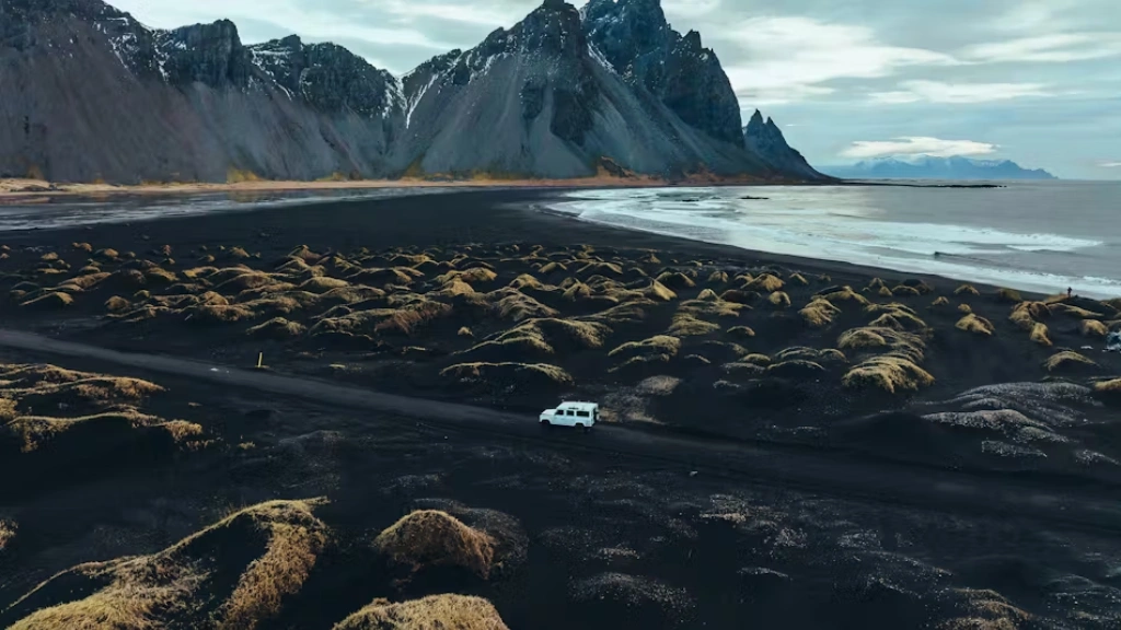
• Key sights: Geysir, Gullfoss, Seljalandsfoss, Skógafoss, Reynisfjara, Skaftafell, Jökulsárlón, Diamond Beach, Vestrahorn
• National Parks: Þingvellir, Vatnajökull
• Scenic Routes: The Golden Circle, The South Coast, The South Coast Lighthouse Trail
• Local specialties: langoustines, local vegetables, craft beers, fresh seafood
The Heat Is On — Geothermal South Iceland
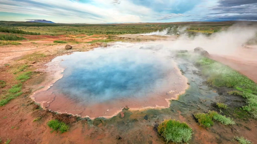
The southwest of Iceland sits on top of one of the most geothermally active zones on the planet. That energy does not go to waste. It heats homes, powers swimming pools, grows vegetables, bakes bread underground, and erupts periodically from the earth in the form of geysers, fumaroles, and bubbling mud pots. Nowhere is this more concentrated or more visible than in the Golden Circle area.
The Geysir Geothermal Area
The Great Geysir gave its name to every geyser on earth — the word itself is Icelandic. Though Geysir itself now erupts only rarely, its neighbour Strokkur fires a column of boiling water 15 to 40 metres into the air every five to ten minutes with reliable, crowd-pleasing regularity. Around them, the geothermal field seethes with hot springs, sulphurous mud pots, and steaming vents. It is geology in real time, and one of the most active-feeling places in Iceland.
Hot Springs, Pools, and Geothermal Baths
The geothermal richness of the south produces some of Iceland’s finest bathing experiences. The Secret Lagoon in Flúðir is the country’s oldest swimming pool, its warm waters surrounded by steaming springs and a small geyser that erupts every few minutes. Laugarvatn Fontana, on the shores of a lake in the Golden Circle, sits directly above geothermal springs and offers hot pools, steam rooms, and — on certain days — the chance to taste rye bread baked underground in the warm earth.
For those who prefer their bathing a little wilder, the Reykjadalur Valley offers a beautiful hike to a natural hot river where you can soak in the open air surrounded by steam and mountain views. Further into the interior, the Kerlingafjöll mountains form one of Europe’s largest geothermal areas — a landscape of colourful rhyolite ridges and steaming hot springs that rewards the effort required to reach it.
The Garden of Iceland — Geothermal Agriculture
The South produces more than 66% of Iceland’s greenhouse vegetables — tomatoes, cucumbers, peppers, and herbs grown year-round in geothermally heated glasshouses. The towns of Flúðir, Hverargerði, and Reykholt are at the heart of this agricultural zone, and some greenhouses welcome visitors. Combined with the local milk and lamb from surrounding farms, the freshly caught fish of the day, and the South’s celebrated langoustines, the region has a genuinely distinctive food identity.
The craft beer scene has also taken root here, with local breweries including Ölverk, Smiðjan Brugghús, Ölvisholt Brewery, and Brothers Brewery producing some of Iceland’s most interesting small-batch beers. The town of Selfoss — the largest in the South — makes an excellent base and a natural stopping point for food and drink.
Waterfalls, Beaches, and Glaciers — The South Coast
The South Coast of Iceland is one of the world’s great drives — a corridor of natural wonders lined up along Route 1 between Reykjavík and the glacier. Allow two full days minimum. Most people wish they had allowed three.
The Waterfalls — Iceland’s Most Spectacular
Seljalandsfoss is the waterfall you can walk behind — a curtain of water falling 60 metres from a cliff edge with a path cut into the rock directly behind the cascade. It is wet, atmospheric, and completely extraordinary. A short walk along the cliff face leads to its neighbour Gljúfrabúi, hidden inside a narrow gorge — far fewer visitors find it, and those who do feel they have discovered something the guidebooks missed.
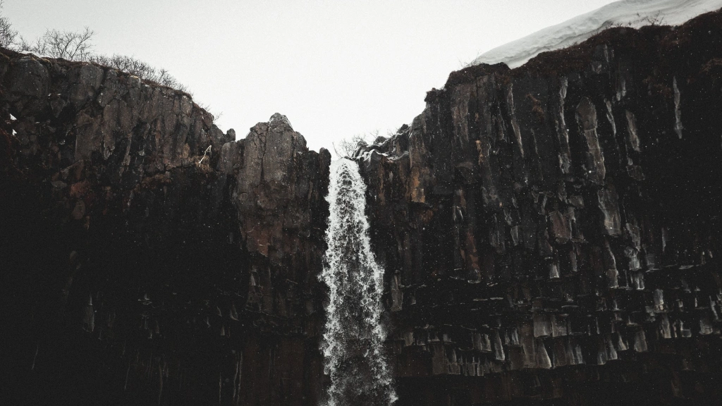
Skógafoss is one of Iceland’s widest and most powerful waterfalls — 25 metres across and dropping 60 metres in a single vertical column, generating a permanent rainbow in sunshine. The 527-step staircase to the cliff top rewards the climb with a view along the entire South Coast. Further east, Svartifoss in Skaftafell falls over a semicircle of perfectly formed black basalt columns, its dark geometry unlike any other waterfall in the country.
And then there are the lesser-known ones — the waterfalls with no names on most maps, tumbling from cliff edges into the sea or hidden in side valleys along the South Coast. They are there for those who stop looking and start exploring.
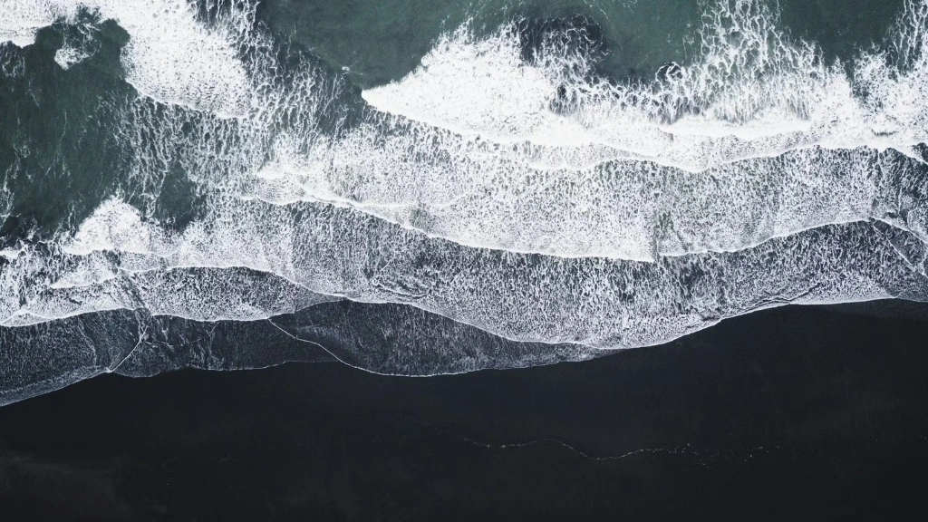
The Black Sand Beaches — Raw, Beautiful, Dangerous
Reynisfjara, near Vík, is the most dramatic beach in Iceland and one of the most visually striking beaches in the world. Black volcanic sand stretches in both directions, backed by towering basalt column formations and overlooked by the Reynisdrangar sea stacks rising from the surf like the fingers of something enormous pulling itself from the ocean. Katla volcano looms in the background. The waves are monumental.
A word of caution that we always give our guests: Reynisfjara and the nearby Kirkjufjara beach at Dyrhólaey are genuinely dangerous. The Atlantic waves here are unpredictable, powerful, and have killed visitors who stood too close to the water’s edge. Stay well back from the surf, never turn your back on the ocean, and follow the safety guidance posted at the beach.
From the top of Dyrhólaey — a 120-metre promontory with a famous rock arch at its tip — you get one of the finest panoramic views in South Iceland: black beaches stretching in both directions, the sea stacks of Reynisdrangar to the east, and in summer, puffins nesting in the cliff face directly below your feet.
The Glaciers — Europe’s Greatest Ice
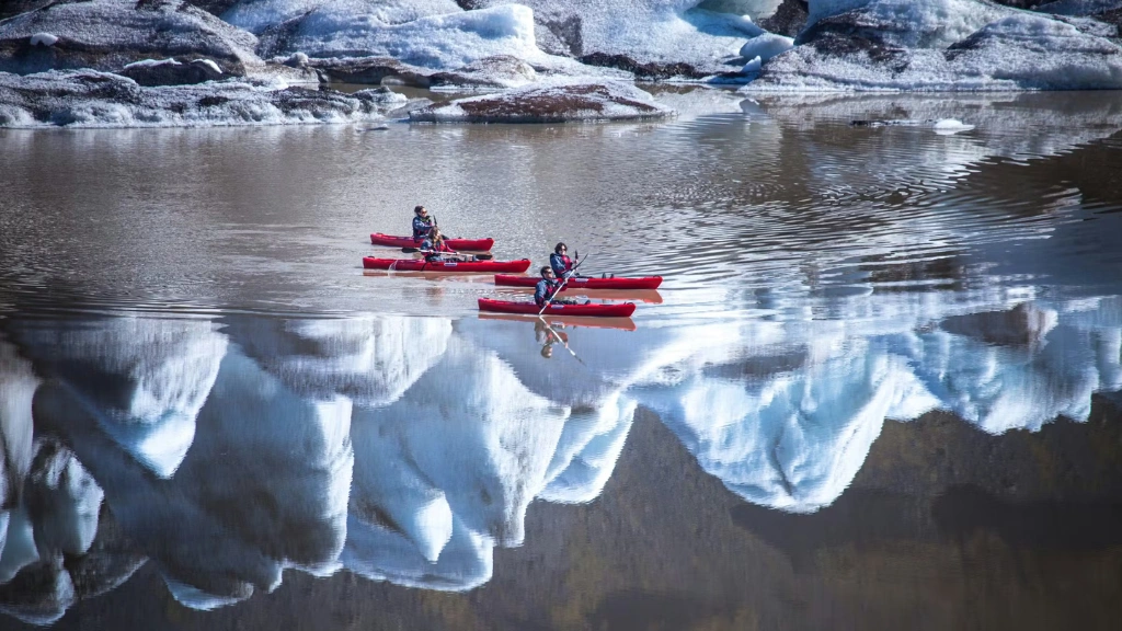
Vatnajökull covers 8% of Iceland’s total landmass and is the largest glacier in Europe. Its southern edges produce some of the country’s most accessible and dramatic glacier experiences. At Skaftafell, glacier walks and ice climbing tours take you directly onto the ice. At Svínafell lagoon, kayak tours navigate between small icebergs calved from the glacier face.
Jökulsárlón is Iceland’s most photographed location — a glacier lagoon filled with icebergs in every shade of blue and white, drifting slowly toward the sea on a current that has existed since the glacier began retreating in the early 20th century. Boat tours bring you up close to icebergs that may be centuries old. Just across Route 1, Diamond Beach at Breiðarmerkursandur is where those same icebergs wash ashore on black sand, creating sculptures of ice and light that change by the hour.
Hiking, History, and Island Hopping
Hiking — From Volcanic Highlands to Glacier Edges
The South contains Iceland’s most celebrated hiking routes. The Laugavegur trail — running from the colourful rhyolite mountains of Landmannalaugar through steaming geothermal fields to the green valleys of Þórsmörk — is widely considered Iceland’s finest multi-day hike and one of the great trail experiences in Europe. Its natural continuation, Fimmvörðuháls, pushes through dramatic volcanic terrain created by the 2010 Eyjafjallajökull eruption before descending to the coast at Skógar.
Within Vatnajökull National Park, Skaftafell offers a network of well-maintained trails through birch woodland and glacier viewpoints, with the remarkable Svartifoss waterfall at the end of one of the most popular routes. The Þjórsárdalur valley, in the shadow of Hekla, provides quieter, less-visited terrain for those who prefer solitude over signposted paths.
The Westman Islands — Puffins, Volcanoes, and a Living Eruption Story
The Westman Islands are fifteen volcanic islands off the South Coast, of which only Heimaey is inhabited. They are reachable by a 35-minute ferry from Landeyjahöfn harbour or a short flight from Reykjavík — and they are worth every minute of the journey.
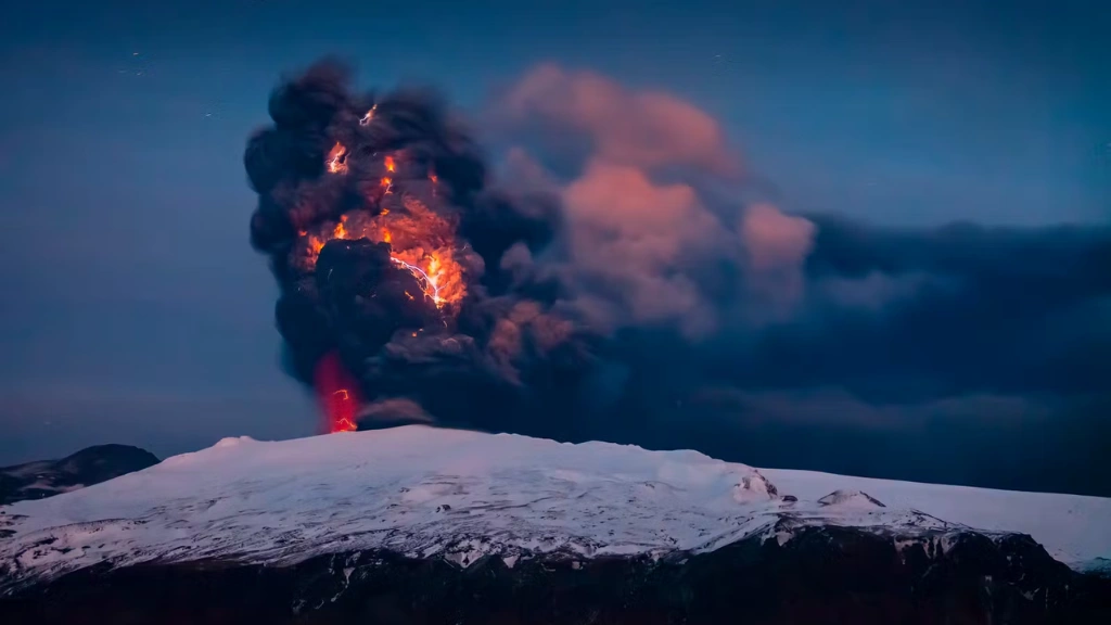
Heimaey is home to the world’s largest puffin colony, a beluga whale sanctuary, and a first-rate museum dedicated to the 1973 Eldfell volcanic eruption — an event that forced the evacuation of the entire island overnight and buried a third of the town in lava. The story of how the islanders returned and reclaimed their home is one of the most extraordinary chapters in modern Icelandic history.
Eighteen kilometres further out to sea lies Surtsey — Iceland’s newest island, born in a volcanic eruption in 1963 and now a UNESCO World Heritage Site. Accessible only by scientific permit, it has been one of the world’s most closely watched experiments in how life colonises new land. You cannot visit it, but knowing it is out there, still growing, still being studied, adds something to the view from Heimaey’s cliffs.
History — The South’s Viking and Volcanic Past
The South of Iceland is soaked in history. Þingvellir National Park — a UNESCO World Heritage Site — is where Iceland’s Viking settlers founded the Althing in 930 AD, the world’s oldest surviving parliament, in a rift valley where two tectonic plates are slowly pulling apart. The park is as historically significant as it is geologically dramatic.
Along the South Coast, the locations of Icelandic Sagas are marked in the landscape. Viking age longhouses have been excavated at Stöng in Þjórsárdalur — buried by a Hekla eruption in 1104 and preserved almost intact. Museums throughout the region celebrate the artists, writers, and ordinary farming and fishing communities whose lives shaped this part of Iceland over a thousand years.
The South Is Where Iceland Begins — and Often Never Ends
For most visitors, the South is where Iceland first becomes real. It is close enough to Reykjavík to reach quickly, dramatic enough to leave a lasting impression, and varied enough to fill a week without repeating yourself. It is where the geysers erupt and the glaciers calve and the waves crash against black sand and the waterfalls fall.
But the South is also where Iceland reveals its depth — in the quiet valleys behind the famous viewpoints, in the farms that have been worked for a thousand years, in the small towns where local life continues entirely on its own terms regardless of how many tourists pass through on the Ring Road.
At Ice Land Paradise Tours, we know both sides of South Iceland — the iconic and the hidden. Let us show you everything it has to offer.
The South Coast is waiting. It always is.